News from campus and beyond
How cities can push back against climate change
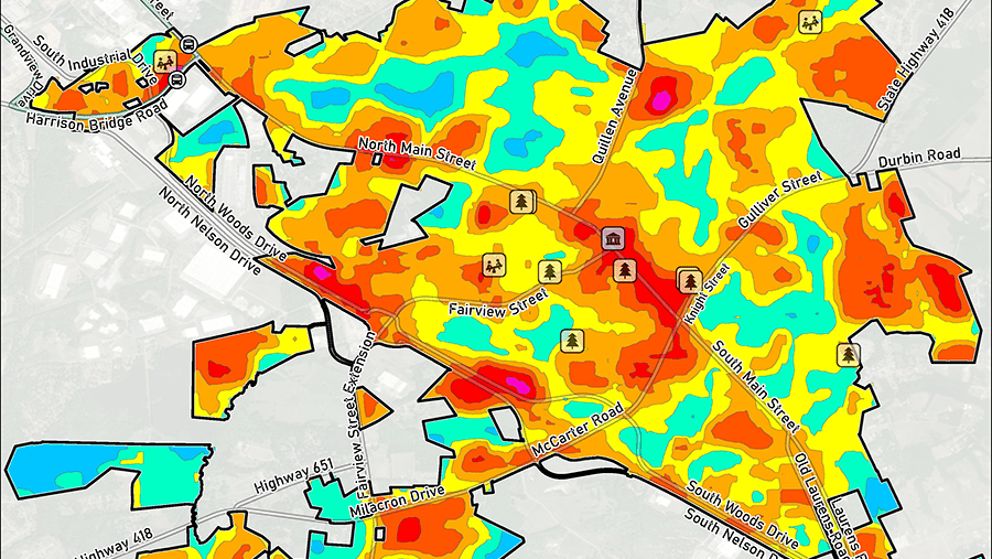
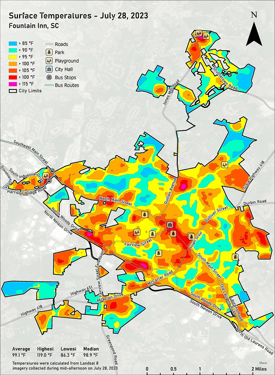
This map produced for this project shows the temperatures across the City of Fountain Inn on July 28, 2023. The magenta portions reflect temperatures greater than 115 degrees, red greater than 105, orange greater than 100, yellow greater than 95, aqua greater than 90 and blue greater than 85.
Climate change means more severe weather that will impact communities from the Upstate to the Lowcountry through extreme heat, floods and other natural disasters.
But local governments can blunt some of the effects by making their communities more resilient, according to Geoffrey Habron, a professor of sustainability sciences at Furman. And thanks to a grant from the National Oceanic and Atmospheric Administration, he and a group of students worked with the City of Fountain Inn to incorporate climate resilience measures in the city’s comprehensive master plan.
Professor Geoffrey Habron
The goal of the grant – made to several universities, including Furman, which comprise the Carolinas Collaborative on Climate, Health and Equity – is to promote more climate resilience in the Carolinas.
South Carolina passed a law in 2019 requiring cities and counties to address climate resilience in their plans – along with traditional elements like economic development and housing – to prepare for climate risks like flooding, Habron said.
This past spring, Habron and four students in his Resilience and Adaptation class, offered to help Fountain Inn, which had begun work on its plan this year, he said.
Using guidance from NOAA, the students put together a draft with areas of possible concern, including vulnerable populations and storm water infrastructure.
Subsequently, he enlisted Furman’s Shi Institute for Sustainable Communities, and the result was a series of maps detailing the city’s temperature contours, impervious surfaces, tree canopy coverage and more to help in its planning.
“Flooding and heat have disproportionate impacts on certain people – low-income people, African Americans, older people, people with disabilities,” Habron said. “But some people can only afford to live in those (most affected) areas.”
The maps help identify them and the role of climate change.
“As we all know, the temperature of South Carolina is getting warmer,” said Shawn Bell, city administrator of Fountain Inn. “And they showed how different parts of our city are hotter than others. And some recommendations to make them cooler.”
Among them is adding shade trees to a sweltering concrete environment, Habron said.
Strategic tree planting
“If you plant in the right spot, trees can grow for a long time, and not just offer benefits from shade but also do a good job of releasing heat away from the ground, helping to mitigate storm water runoff, and absorbing carbon dioxide from passing traffic” said Jack Buehner ’23, an earth and environmental science major who is now a project coordinator and GIS (geographic information system) analyst at The Shi Institute as a post-baccalaureate fellow.
“There’s a lot that goes into resiliency,” said Bell. “And this was kind of uncharted waters.”
While the students graduated before the maps were produced, the project gave the students the real-world experience of getting feedback from a city about their work, Habron said.
Jack Buehner ’23, project coordinator and GIS analyst at The Shi Institute for Sustainable Communities
“Our role became helping to build on the work that his class created,” said Buehner, “and we ended up deciding to do resilience maps.”
The map that details high-heat areas also shows the proximity of public transportation and the distances residents must walk to access it, he said adding that that information could lead to improvements such as walking paths in shady areas.
“When everything is concrete and asphalt and its over 100 degrees in mid-July, you could have some bad outcomes,” Buehner said. “And in the Southeast, where we have high humidity too, it’s going to get worse.”
Growing urgency
Other possible measures communities can take to reduce heat include covering parking lots in solar panels, he said. The best time to develop resilience plans would have been earlier, Buehner said.
“But the second-best time is now,” he added.
Eventually, all cities and counties will have to include resilience as they update their plans, Buehner said, and Fountain Inn can be a model.
The city will hold public hearing on the plan in December, and a City Council vote could occur in January.
“Our consultants and city were extremely impressed with the things that Furman provided us,” said Bell. “One of the first things we will do after we adopt it is start working on revamping our zoning and land development regulations. We would like to make sure that any subdivisions coming in are required to add things like street trees.”